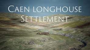
Caen Longhouse Settlement
Dublin Core
Title
Caen Longhouse Settlement
Description
A Collaborative project between Open Virtual Worlds, research team within the School of Computer Science, University of St Andrews and Timespan.
Virtual Reconstruction and Film: Sarah Kennedy
Digital Curation, Archaeological Research and Narration: Jacquie Aitken
Character Animation: Lucy Hardie
Digital Systems: Iain Oliver
Digitisation of feature objects: Catherine-Anne Cassidy
Project Coordinator: Alan Miller
The settlement of Caen is located a few miles north of the fishing village of Helmsdale along the Strath of Kildonan road. It is located in a narrow valley along the banks of a tumbling burn that flows into the Helmsdale River. The presence of Neolithic stone burial cairns and Iron Age roundhouses in the vicinity shows us that people had been farming this land for over 6,000 years.
In 1230AD, the lands of Kildonan formed part of the Earldom of Sutherlandshire, a part-feudal land-owning system created by Alexander II, who granted the lands to William de Moravia, the 1st Earl of Sutherland. This system prevailed relatively unchanged until the early 19th century when the landowners implemented a major plan of improvements instigated by technological and agricultural advancements led by a wealthy class of aristocrats known as improvers.
The people of Kildonan were removed from their homes and relocated to the coast at Helmsdale and were allocated small strips of land to work on the steep stony hillsides, next to the sea. The hilly uplands in Kildonan were used to graze huge flocks of cheviot and blackface sheep, whose wool had tripled in price due to high demand in Britain and Europe.
The reconstruction of the township of Caen gives us an authentic insight into the daily life of a farming community, before the Clearances.
Contributor
eulac3d
Format
video/mp4
Type
Moving Image
Europeana
Object
https://player.vimeo.com/video/428461938
Europeana Type
VIDEO
Moving Image Item Type Metadata
DescriptionEN
A Collaborative project between Open Virtual Worlds, research team within the School of Computer Science, University of St Andrews and Timespan.
Virtual Reconstruction and Film: Sarah Kennedy
Digital Curation, Archaeological Research and Narration: Jacquie Aitken
Character Animation: Lucy Hardie
Digital Systems: Iain Oliver
Digitisation of feature objects: Catherine-Anne Cassidy
Project Coordinator: Alan Miller
The settlement of Caen is located a few miles north of the fishing village of Helmsdale along the Strath of Kildonan road. It is located in a narrow valley along the banks of a tumbling burn that flows into the Helmsdale River. The presence of Neolithic stone burial cairns and Iron Age roundhouses in the vicinity shows us that people had been farming this land for over 6,000 years.
In 1230AD, the lands of Kildonan formed part of the Earldom of Sutherlandshire, a part-feudal land-owning system created by Alexander II, who granted the lands to William de Moravia, the 1st Earl of Sutherland. This system prevailed relatively unchanged until the early 19th century when the landowners implemented a major plan of improvements instigated by technological and agricultural advancements led by a wealthy class of aristocrats known as improvers.
The people of Kildonan were removed from their homes and relocated to the coast at Helmsdale and were allocated small strips of land to work on the steep stony hillsides, next to the sea. The hilly uplands in Kildonan were used to graze huge flocks of cheviot and blackface sheep, whose wool had tripled in price due to high demand in Britain and Europe.
The reconstruction of the township of Caen gives us an authentic insight into the daily life of a farming community, before the Clearances.
Collection
Citation
“Caen Longhouse Settlement,” Digital Open Doors, accessed February 7, 2026, https://ddo.openvirtualworlds.org/omeka/items/show/4069.
Embed
Copy the code below into your web page
